This old blog lists my John o'Groats to Land's End Walk in 2009 and may be of use to others undertaking a similar walk.
There is also a record here of a second long walk following Offa's Dyke in 2010. This was the first long walk with my wife Shiel.
In 2011 we walked from Hull to Robin Hood's Bay via the Wolds and Cleveland Ways and then took the train North to Newcastle and walked the Hadrian's Wall path. There is no record of this walk as rain water entered and destroyed my cell phone before we reached Filey.
From 2012 to 2014 we followed the Labe /Elbe from the source to the sea.
In 2015 we walked the Leeds to Liverpool Canal and a second walk around the Isle of Wight.
In 2016 we followed the river Severn from its source near Plynlimon, in Wales, to Severn Bridge on the Severn Estuary.
In 2017 we followed the Wye river. It rises very near the source of the Severn, in Wales. We followed it to Chepstow.
Details of ALL these walks can be found here :- Recent Walks
Thursday, July 7, 2016
Monday, August 30, 2010
Day 19. Sodom to Prestatyn.
Preamble: Over the last two or three days, at times, I've had difficulty getting my leg over. Even Shiel commented on it. I think it is something of which the Offa's Dyke Association should be made aware. Although most stiles have steps of sufficient height that one's boot reaches over the top board on the stile, the stile is sometimes too narrow to accommodate the length of leg from knee to boot. This results in an unstable crossing of the stile when one's boot hits one of the upright supports. The stone stiles on the last day, although of interest in their own way, were particularly plagued with this problem. This is not a trivial matter. Our landlady a few days ago told of one group that had to abort their walk because one of their party broke an arm whilst attempting to cross a stile.

The Walk: We had an early start, 8:40am, in clear but cool weather. I was wearing my polypro for the first time. We started to climb shortly after leaving our B&B (Fron Hall), and within about 10 minutes I decided I also needed my windproof jacket. We had good views back over yesterday's route at this time.
It was a good pull to the top of the hill, Cefn Du, and I was glad we stayed at Sodom and not further down the hill in Bodfari. Climbing out of Bodfari to Cefn Du on a full stomach does not bear thinking about.
Just as we reached the summit the skys darkened, the rain came and the wind intensified. We put on all our wet weather gear. Needles to say, what might have been extensive views were seriously curtailed. The wind rose to almost frightening proportions and in crossing one field, near Rhuallt, we heard an almighty crack and saw a large branch break off an oak tree. Fortunately it was about 30 metres away. By midday the rain eased and the views improved but the wind was still horrendous.
The route into Prestatyn is quite imaginative, and climbs high above the town giving great views out to Snowdonia, and north to Lancashire, but we spent most of our time trying to keep upright in the gusting wind. As Shiel said, 'Now we know why they've sited a wind farm offshore here.' Fortunately the wind was blowing us onto the hillside, and not off it or the walk would have been impossible. On a calm day it must be a really impressive end to the walk. Full marks to the planners.
Having now done the walk I would recommend a south to north crossing to anyone contemplating the walk. Finishing in Sedbury would I think be an anticlimax compared to finishing in Prestatyn.
As we passed our B&B we popped in to report our progress, but continued, fully kitted, to the water's edge in Prestatyn. It was still very windy and it felt like one was in a sandblasting machine. We didn't hang around but took a few photographs and then returned to our B&B (Plas Ifan Chapel. Plas Ifan also have camping facilities and will even provide a breakfast if requested. We met two young guys there who had had great difficulty finding a campsite in Prestatyn until a publican had referred them to Plas Ifan Chapel.

This one is for Graham at RDA. It might help place where we are.

Monday. Walk over. Where are we? Here is a clue.

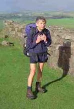
Shiel st the end of her first long distance walk. Note the smile!

Sculpture on the beach at Prestatyn.
Sunday, August 29, 2010
Day 18. Esgairlygain to Sodom.
Preamble: The pub in Llangynhafal was taken over with a Cancer Charity event so we were taken to the next pub down the road for an evening meal. Not a bad meal, but not nearly as good a value as the pub at Llandegla. On returning us to the b&b the owner was going to feed his horses so I asked if I could go along too. A pleasant way to round off the evening.
Walk: We left Esgairlygain at 8:40 in fine sunny weather. The climb back onto the ridge was not too steep, and we were on the tops again in an hour. We still couldn't find the path down, shown in green on the OS map, at the top end of the route near the finger post. The way down seems to use the much fainter dotted path on the map. Not far rom the top though the path, when found, is clearly marked.
It remained clear but windy, and we had excellent views from the ridge. There were quite a few people out walking, mainly sourced from the two car parks we passed along the way. We did however meet two Offa's Dyke walkers, Chris and Graham, walking the path in aid of NSPCC in only 10 days. I thought that I was a heavy packer but Chris makes me look like a light packer, he was carrying 60 lbs.
There were many ups and downs to hill forts and it was a great walking day, if a little cool. We had one hard shower on our descent into Bodfari where we had a snack outside the shop. We had been told, incorrectly, that the pub wasn't open. There then followed a short, but steep climb to Fron Haul our b&b.
We went down to the pub for an evening meal and were offered a lift back, but we decided to walk. Without our packs it was a pleasant walk back. I think even Shiel may have enjoyed our penultimte day.

Chris & Graham

The frame has snapped on my Osprey rucksack!
Friday, August 27, 2010
Day 17. Llandegla to Esgairlygain (Llangynhafal)
Preamble. Last night we stayed at The Hand b&b in Llandegla. They very kindly ran us to the nearest pub, The Plough, for our evening meal. We each had an excellent meal at a remarkably cheap price. Service was good and the pub is well worth a visit if you are staying in Llandegla. We walked back from the pub to the b&b in about 15 minutes.
The breakfast at The Hand this morning had to be the most imaginative of the trip and we've had some good breakfasts. Fresh fruit followed by salmon and scambled egg and finishing with pain au chocolate, toast, coffee and honey.
The Walk. Today we were casting shadows fom our first steps. A sunny day all day. We crossed mainly flat farmland to start with before gradually climbing up towards Moel y Plas. We then skirted around Moel Llanfair with great views to the west. We then skirted Moel Gyw before coming down to the busy A494.
A climb to Moel Eithinen was followed by a climb to Foel Fenlli, but this hill fort was skirted rather than fully ascended, but great views were had along the way. We then descended to a very busy carpark at Bwlch Penbarra. Remember today is bankholiday Friday. We then had a 2 .8km climb to the summit of Moel Famau, the highest peak in the Clwydan range. The climb was pretty gradual but for the last few metres (horizontal). At the top, there were great views from the Jubilee Tower in all directions. We could see Snowden, Liverpool and Jodrell Bank amongst many other well known landmarks. It turned a little cool on top so we donned our windproof clothing to walk north along the ridge before our descent to Esgairlygain. Finding the path down from the ridge was not a trivial task but we reached Esgairlygain by 5 pm having left Llandegla around 9am.
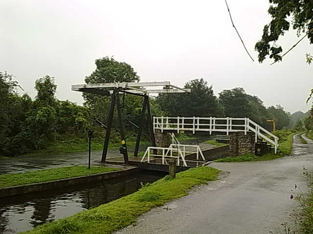
Swing bridge on Llangollen canal.

Were you hoping to cross here?

Eglwyseg crags.

Path repair work by Denbighshire council. Note the wheelbarrow!
Day 16. Froncysyllte to Llandegla.
Preamble: Last night we stayed at yyyy a b&b right on the path just before Froncysyllte, and the Llangollen canal. We had an excellent meal and a good chat with Pat and Malcolm our hosts. A great place to stay and they will even do your washing. Another good reason to use our 3 day route choice from Llanymynech to Llandegla.
Today's walk: It was the best of days and the worst of days. For the first time we wore our waterproof clothing all day. The rain was only heavy a few times but the drizzle was persistant. We never saw our shadows once.
That having been said I think today was probably the most impessive day's walking we've had so far. For those who have walked the Pennine Way it was a combination of High Cup Nick and the Swaledale walk from Thwaite to Keld. Magnificent scenery even on a wet day. On a sunny day it must be incredible.
The day started with a pleasant walk along the Llangollen canal. We then joined the road to go to the bridge over the Dee from which one can get a very good view of Thomas Telford's aqueduct, built in 1805.
We then had a long but gentle climb to the road from which there were good views of Dinas Bran and the Dee valley. The road walk was about 3 miles, but we only met one car on the walk. We then walked on north, on the scree, beneath the Eglwyseg crags. Probably the most exilharating part of the walk so far.
On the path we met a group of 'Offa's Heroes' who were maintaining the path for the Denbighshire council. They had managed to get a wheel barrow where we had had difficulty just getting ourselves down.
We rejoined the road, in heavier rain to climb onto the moor. We eventually turned off the road to cross the moor to a pine plantation through which we descended to Llangedla, and Hand House our b&b for the night.
Wednesday, August 25, 2010
Day 15. Quarry Farm to Froncyscyllte.
Preamble: In the guide book the recommended route is shown from Llanymynech to Chirk Mill at 14 miles, and then from Chirk Mill to Llandegla at 15.5 miles.
As Shiel is new to walking I have tried to limit our walking days to less than 12 miles. We will therefore take 3 days to get from Lanymynech to Llandegla. Shiel also likes visiting castles and with our choice of route we were able to spend 2.5 hours today looking around Chirk Castle.
Today: As we were having a short walking day we didn't order breakfast until 9:00am. As a result it was after 10:00am before we bid goodbye to Beryl and Peter after a very enjoyable chat over breakfast.
The day was overcast but there was no wind or rain and we had a pleasant 3 hour walk to Chirk Castle. We looked around the castle and gardens for over two and a half hours and even had time for tea. I would recommend our route choice to all walkers who are more interested in seeing the UK than getting from Sedbury Cliffs to Prestatyn in record time. Our route also allowed us to visit some great b&b establishments.
We arrived at Chirk Castle on a permissive path and attempted to leave on the same path. However, unbeknown to us there is more than one permissive path at Chirk Castle, and we picked the wrong one! We eventually realised our mistake, but we had walked about an extra km as a result. We arrived at our b&b, Cloud Hill, at 4:30 pm. Two and a half hours later we had an excellent evening meal cooked at the same establishment.
Tuesday, August 24, 2010
Day 14. Llanymynech to The Quarry, Selattyn.
We left the b&b at around 9am and headed for the post office where I got a £20 voucher for my 'orange' blog-o-phone. We were delayed slightly, first by Shiel having water leaking from her pack and secondly by me deciding to polish the toes of my boots. I think the technical term for these procrastinations is;- 'a faff.'
It was sunny but very windy when we eventually left Lanymynech around 9:30am, and started our ascent of Llanymynech Hill. There were good views of interesting rocky outcrops before we finally arrived at the golf course. Whilst rain threatened it held off all day and we never needed our waterproof clothing. The first ascent of the day though, over Llanymynech Hill, was marred by the overpowering smell of slurry borne in on the blustery wind. However, by the time we reached Porth-y-Waen the air had cleared significantly. Then we followed a road walk to Nantmawr, and a climb through woods (Jones's Rough) to the top of Moelydd where we had extensive 360 degree views. There seemed to be a lot of rain on the horizon, especially out west, but we escaped it.
We headed down for lunch in Trefonan, where a dead tree has been skilfully carved in the shape of an eagle. The final climb of the day was up though Racecourse Wood where we met up with Bill and Peter who are walking Offa's Dyke in stages over a number of years. We had passed them earlier in the day in the company of their wives, Jill and Susan, who had now travelled on ahead to pick them up near the car park at the old Oswestry Racecourse.
We had a good chat with them, whilst climbing to Racecourse Common, which made the climb so much less tiring than we had feared. We stopped at a plane table near the racecourse ruins, but all the views are now obscured by new tree growth. Then there was an easy walk to our b&b, The Quarry, near Carreg-y-big.

Black eyed sheep. Black ears, nose and feet.
Monday, August 23, 2010
Day 13. Welshpool to Llanymynech.
Started walking north by the canal to meet up with Offa's Dyke path. We spent the first two hours taking waterproofs on and off in the intermittent rain. The rain then eased and we had a clear run until two minutes before we arrived at the b&b.
The route was mainly flat walking over farm land following a river stop bak, and the eventually Offa's Dyke. A lot of concentration was needed to avoid treading in cow pats or sticking the walking poles in them. We saw three families of swans one pair having seven cygnets.
There were plenty of ripe blackberries along the route and at one point a landowner was giving away apples to passing walkers.
As it was a short day we stopped for lunch at the Golden Lion in Four Crosses to pass the time.
Day 12 Welshpool.
Beautiful sunny day sightseeing in Welshpool.
We walked to Powis Castle and spent the afternoon looking around the castle and gardens. A really enjoyable visit. If you are walking Offa's Dyke it is well worth taking an extra day to visit the castle and gardens.
In the evening we had a very good meal in the Royal Oak.

Powis Castle.

Swans with young on Montgomery canal
Sunday, August 22, 2010
Day 11. Montgomery to Welshpool.
The day started in sunshine with a walk past the show ground where people were making preparations for the annual Montgomery show. It looked like being a good day.
We quickly joined the Offa's Dyke path and headed north. We had fine weather for two hours, until we were just starting to climb, when the rain started and continued on and off for the rest of the day. We were well soaked, but the rain did ease slightly as we reached the top of Beacon Hill, and we even managed to get one or two photographs, but visibility was limited. However we were able to make out Powis Castle just south of Welshpool.
At Buttington Bridge we turned South to pick up the path beside the Montgomery canal to Welshpool and our b&b. We were then at last able to remove our waterproof clothing. However 24 hours later, as I write this, our boots are not yet dry enough to take polish! Not one of our better days.

Rabbit or badger damage to Offa's Dyke?

Offa's Dyke.

Road sign seen near Montgomery show ground

Amusing sign seen near Welshpool

Offa's Dyke path? (Just before Buttington Bridge)
Subscribe to:
Posts (Atom)