About my blog

CLL is the acronym for Chronic Lymphocytic Leukaemia. CLL is the most common cancer of the blood. However, unlike many other leukaemias, CLL is incurable. Innovative research is desperately needed to provide treatments which are more effective than the derivatives of chemical warfare agents currently in use. Research however costs money.

In 2009 I walked from John o'Groats in the north east of Scotland to Land's End in the south west of England. Hence the acronym JOGLE. The purpose of my walk was to make more people aware of this insidious disease and to encourage them to sponsor me by donating to the research groups I was supporting. It was a most enjoyable experience and I met some wonderful people. Together we raised over 2000 pounds for the cause. Thank you everyone!

In, 2010, the blog was being continued for those who may have be interested in following my walking holiday in Wales. This was not a charity walk.

Sadly this year, 2013, Alan Frost, a senior member of the Wednesday Loafers, our cancer support group, passed away. Many medics will tell you that CLL can be cured by a bone marrow transplant. Alan had battled with the cure for many years. More research is needed, but significant progress has been made since I started this blog.


CLL is still killing my friends. The organizations listed at the side of this blog would welcome any contributions you would like to make towards their research.

Please feel free to pass on the details of this site to anyone you think may be interested. The link is www.cancerwalker.com
_______________________________________________


Wednesday, September 9, 2009

Day 65, Botallack to Land's End (Planned: Balnoon to Land's End), Wed 9 Sep

Summary
Today's Distance: ~25.8 km (16 miles)
Total Distance: 1628 km (1012 miles)
Distance to go: 0 km (o miles)

Report
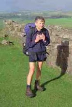
Shiel put me down on the road outside Botallack at 8:40am and the final day of my walk had begun. What a contrast to yesterday. I could see where l was heading! Extensive views in every direction. Yesterday's walk would have been much more interesting in sunny weather.
I took the B3306 into St. Just, l missed the more direct route yesterday. However had l found it l wouldn't have met up with Shiel.

I took a small road out of St. Just, heading for the YHA in the Cot Valley and then a path up to the SWCP. Looking at the map now I see that the route I took was not exactly the one l'd planned. It's good to see that some things don't change.

I had a very pleasant and sunny walk along the SWCP to Sennen Cove where I am writing up the first part of this report. I'm in no hurry for once. It's only 12:15 and l've only 1.5 miles to go to Land's End.

I've just heard from my sister Kathleen that they are all waiting for me at Land's End so l can finish the walk...

I finished the walk at about 2:45pm and had an expected reception from Shiel, my sister Kathleen and brother-in-law Robin. An added boost however was that Kit and Sally were also there to greet me! They had driven down from Devon, about 150 miles, just to cheer me in. They even brought a donation with them from their friend Martin who they had told about my walk. Regular readers will remember that Kit and Sally came to take me out for an evening meal when l was in Devon. Kit was treated for PLL, a very rare form of leukaemia.

It is the generosity and friendship of such people, and others like them, who only two weeks ago were complete strangers, that will be my lasting memory of this walk. You hear and see so much gloom and doom in the press that you get a jaded outlook on humanity. To improve your outlook on life:-
1. Sell the TV
2. Stop reading the papers.
3. Undertake a walk for a charity.
You'll also be able to 'come off' the Prozac.

I will sum up in a few days time and also add some comments on kit and maps which hopefully will be of help to others. I will continue accepting donations until we return to New Zealand in early October.

Photos  -- check out page 5 and 6 of photo album for a few more photos

Day 64, Gwithian to Botallack (Planned: St. Agnes to Balnoon), Tue 8 Sep

Summary
Today's distance: ~33.8 km (21 miles)
Total distance: 1603 km (996 miles)
Distance to go: 26 km (16 miles)

Report
We had breakfast at 7:30 am and I was back on the road, just before Gwithian, at 8:40 am. The weather was overcast, tending towards rain. I reached Hayle in good time and stopped to take a photograph of the memorial to Rick Rescorla (?) who was born in Hayle and lost his life helping fellow employees in the evacuation of one of the twin towers during the 9/11 terrorist attack. I thought it might be of interest to my readers in the US, including my son Colin, who organises this blog, and now resides in Connecticut.

While taking the photograph l was spotted by a friend of Ricks who provided me with extra information about him and mentioned the fact that there is a website dedicated to his memory. He also pointed me towards a pictorial display of some of Hayle's interesting industrial history.


He also gave me dire warnings against following my proposed route across the moors. I took the road to Lelant Dons with one of my famous ''long cuts'' near Splattenridden. I stopped someone, Nick Ridge, to get local knowledge on my plannd route and he did not seem phazed by it. He also very kindly gave me a donation.

A little further down the road I met up with Chloe and Simone, two sisters down from London, who were out for a walk. They acted as my guides to near Nancledra and suggested my original route, via Amalveor, would be the easiest to follow on the ground. Walking with them was really enjoyable and boosted my morale for the day.

The boost was to be short lived however as l arrived at Amalveor to find the path obstructed with path closed signs. I rang the number on the sign to get detailed information but no one was in the office who knew about the closure, set up in April. The girl in the office rang back but only seemed to have details of a SWCP closure. I wonder if the sign was put in the wrong place as it talked of a slip near a cliff and no cliffs are visible on my OS map of the path west from Amalveor. In the end I decided to follow a parallel path about 1km south, starting from Embla.

I got to the farm road just north of Borifty without too much of a problem and found a path, not shown on the OS map that finished up near Tredinnick. Visibility was quite poor but by good fortune someone from the farm was arriving by car and I got useful information from her. I headed on a path to Lanyon Farm but took the wrong path at a fork. This added a few 100metres to my walk but I didn't mind as Lanyon Farm do cream teas, and they had no scone shortages! Recharged, I headed NW up the road towards the turn off to Little Bosullow, where I met up with Shiel.

Although the rain was now quite heavy l decided to walk on south west towards Tregeseal. I knew I would get the wrong path among the plethora of paths near Carn Keidjack, and get the wrong path I did. I finished up just south of Carnyorth. However I could see the farm builings and decided it would be quicker to walk on a farm access road than walk on the very boggy paths across the moor.

I met up with Shiel at Botallack from where I head via St.Just to Land's End tomorrow. Todays walk was long, at 9 1/4 hours but I find it easier now to continue a long day rather than get up early the next morning. The end is in sight and I've not yet told you of my observations of single industrial gloves, seen on at the side of many roads, or of my conversations with sheep and cows.

Monday, September 7, 2009

Day 63, Perranporth to Gwithian (Planned St. Coulomb Major to St. Agnes), Mon 7 Sep

Summary
Today's Distance: ~30 km (18.7 miles)
Total Distance: 1569 km (975 miles)
Distance to go: 60 km (37 miles)

Report
Breakfast at 7:30am and back on road at Perranporth sea front at 8:35am. My first day back on the South West Coast Path. l found this first section to the outskirts of St. Agnes a little vertiginous, but l'm sure most people would have no problem with it. I left the SWCP near Cross Coombe and headed via Wheal Kitty and the outskirts of St. Agnes through the Cemetary and a good path to Mingoon (?). I stopped at the shops in St. Agnes and bought a bottle of milk shake which l drank on my way to the Cemetary. I took off my pack and jumped on the bottle to sqash it and reduce its size. I then started pushing it into one of the side pockets of my pack. A lady walking by must have been watching all this action and very kindly offered to drop the bottle in a waste bin as she was heading back into town. It never ceases to surprise me how helpful passing strangers can be. Perhaps l've been reading too many newspapers.

I continued on the road through Towan Cross to Porthtowan where l wisely asked directions at a garage. I was informed that my planned route via a disused airfield was not possible as it was MOD land, so at Factory Farm l returned to the SWCP. Then followed a pleasant but at times arduous walk to Portreath. Quite a few steps to go up and down across two small valleys. On the way to Portreath l met Brian and his family out for a walk, we chatted and they very kindly gave me a donation. I stopped at the Portreath Arms for lunch where l received my second donation of the day from Martin. I went wrong when leaving Portreath and finished up heading for Illogan. I eventually found my way out on the B3301 which l followed to a turnoff at Bassets Cove where l joined the SWCP again.

I followed the SWCP to a car park just past Hell's Mouth where l met a Dutchman, another long distance walker, and we chatted for a while about walking. I then followed the B3301, with some care to Gwithian from where l leave for Hayle (and beyond) tomorrow. We had our evening meal in a pub at Phillack where l had the best salad yet supplied as a side dish to lasagne.

Sunday, September 6, 2009

Day 62, Rosenannon to Perranporth (Planned: St. Mabyn to St. Coulomb Major), Sun 6 Sep

Summary
Today's Distance: ~23 km (14.4 miles)
Total Distance: 1539 km (956 miles)
Distance to go: 90 km (56 miles)

Report
Breakfast again at 7:30am and I was placed on the road at Rosenanon at 8:55am. I decided to ignore a footpath shortcut and followed the road via Borlasevath, Tremayne and Tregamere to St Coulomb Major. My experience with short sections of paths later today, suggests l made the correct decision.

l was in St. Coulomb Major by 10:10am and rehydrated with a bottle of chocolate milkshake: 500ml of water, sugar and fat all for less than a pound! The weather improved as l walked on through White Cross and l reached St. Newlyn East by 1:30pm where l had lunch. At Fiddlers Green my troubles began. l wanted to take a path to Scotland Farm and l couldn't find it. The path was shown on my map emerging from the back of a house so l went to the house and knocked on the door. A very pleasant chap came out and said he would take me to where the path started. It was good that he did as l wouldn't have found it without his help. (Sorry l should have taken a photo.) Once l had climbed up onto the path corridor it was easy to follow; fenced on boths sides and just over a metre wide. The going wasn't too bad as some of the vegetation had recently been trimmed by the gentleman to whom l had been talking. Nearer to Scotland farm the track was harder to find and very, very boggy and l could only maintain dry feet by stepping from one clump of bog grass to another.

The next section of path was even more of a problem, but this time largely man-made rather than natural. It was only about 300m in length and joined two farm access roads which are also public footpaths over some of their length. I've attached photographs of the entrance to the path and the electric fences, barbed wire and corrugated iron blocking it (photos coming later). I've also shown how the exit to the path is still quite clearly marked, unlike the entry. I continued to follow paths, which gradually improved, all the way into Perranporth. Perranporth is on the South West Coast Path (SWCP) and l walked the section from Penzance to Minehead in 2006. As a result my feet have actually walked all the way from John o'Groats to Land's End, l've yet to walk it at 'one go' though. Tonight we are staying in a B&B near Goonhavern.

Photos
Go to page 5 of the photo album for new photos

Saturday, September 5, 2009

Day 61, Watergate to Rosenannon (Planned:Wainhouse Corner to St. Mabyn), Sat 5 Sep

Summary
Today's Distance: 32 km (20 miles)
Total Distance: 1514 km (941 miles)
Distance to go: 113 km (70 miles)

Report:
We breakfasted at 7:30am and l was back on the road in Watergate at 8:55am. Rain threatened but did not eventuate and l had an enjoyable walk on quiet country roads. I walked via Tuckingmill to St. Tudy where l arrived in time for an over 60's morning coffee and biscuit. I asked directions and was advised to ask a couple of local ladies. I was told l would have to cross the border.

One of the ladies told me how she had had to cross the border when she got married. However she went on to say that after her husband retired she got him to take her back home across the border. The border in question? The parish border between St. Tudy and St. Mabyn.

From St. Tudy l crossed the border and went via Cross Hill and Castle Killibury to Wadebridge. This required an unpleasant 1km walk beside the A39. l did however meet and chat to 3 cyclists heading north on the A39 on their LEJOG. I arrived in Wadebridge about 1:35pm where l met up with Shiel and we had lunch. Like yesterday we ordered 2 cream teas and were told, like yesterday,that they had only enough scones to make one cream tea. In fact they had insufficient clotted cream to make one cream tea. Is there a national scone shortage? I left Wadebridge via Burlawn and went past the St. Breock wind farm. Near the wind farm, on the Saint's Way, l passed 4 more cyclists starting their LEJOG.

I ended my day at the village of Rosenannon, about 3miles short of St. Mabyn, the end point I originally planned for tomorrow. We are staying at a farm B&B near Winnard's Perch and we had our evening meal at a pub in St. Coulomb Major. A friend of mine in NZ, Murray S, has suggested that my JOGLE walk is just an excuse to make a 66 day, 1000 mile pub crawl. The idea is not without merit.

Friday, September 4, 2009

Day 60, Tamar Bridge to Watergate (Planned: Thurdon to Wainhouse Corner), Fri 4 Sep

Summary
Today’s distance: 29.8 km (18.5 miles)
Total distance: 1483 km (922 miles)
Distance to go: 145 km (90 miles)

Report
Last night we stayed at a farm B&B at Hopworthy. It had very friendly owners who breed quality eventers, two of which have competed at international level. (lt may interest those planning a LEJOG that the cost for each of us last night was less than my staying at the Caravan Club site in Tewkesbury and breakfasting in Witherspoons).
I started walking from the Tamar bridge at 8:45am. The weather was much like the last few days, showery with a strong cold wind, very autumnal. I only met one other backpacker today


and s/he was progressing more slowly than l was. It will probably take many generations to finish it's JOGLE. The roads were quiet and l made good time to Whitestones where l headed south and then south west to Middle Wheatley by which time l was off my map. I had to navigate to Canworthy Water using a 1 in 250,000 car map. It was a much smaller place than l expected, with no lunch place that l could find. I climbed steadily to Hallworthy where l joined the A395 and found a pub so l was able to have a late lunch. After lunch l headed south west for about 3km and then picked up a path to an old airport. From there l headed south west, past the Crowdy reservoir,
Because l have loyal supporters in the US l decided to extend my walk today and instead of ending my walk at the Crowdy reservoir l decided to walk on for a few extra miles. I wanted to end my day(s) with Watergate, like another well-known Richard. Sadly the village is too small for a sign saying 'WATERGATE.' A couple of locals told my wife they took the name plate down during the last war and it never got put back up again. However l did manage to get a photo of the name plate of the local farm.

Day 59, Petrockstow (Dolton) to Whitstone (Thurdon), Thu 3 Sep

Summary
Today’s distance: 23.4 km (14.5 miles)
Total distance: 1420 km (882 miles)
Distance to go: 208 km (129 miles)

Report
We had breakfast at the B&B in Merton at 7:30 am and Shiel deposited me at the cross roads at North Town by 8:30. I headed west along what was at first a busy road but after 9:00am there was an appreciable drop in traffic. I took a path through a wood near Filleigh Moor, to cut off a corner, and continued to Shebbear where l found a small local store open. I was able to buy two orange drinks.

Just before Shebbear l had met two heavliy laden cyclists and had asked where they were headed. They were heading for John o'Groats via Wales and lreland, before taking a ferry to Scotland. We compared notes before heading our separate ways.
From Shebbear l continued west, first via a very boggy path and then via a quiet minor road to Oxenpark, where l then headed south west towards Woodacott and then Holsworthy. I arrived at the A388, 1km north of Holsworthy, just after 1:00pm and found Shiel waiting. We arranged to meet up again near the church and then go to lunch. On closer inspection however l found there were two churches so by the time we eventually met up in the centre of Holsworthy it was 1:50pm. We went to a small cafe for a cream tea each but had to make do with one between us as they only had two scones left. We parted in Holsworthy at 2:55pm with the arrangement that l was to walk to the bridge over the Tamar on the small minor road about 2 miles north east of Whitstone. I made better time than l expected and was there by 4:30pm.

We both then travelled by car to our B&B in Hopworthy where l had a good soak in the bath before we headed for an evening meal at the pub in Pyworthy. To get to Wainstone Corner, the original end point for tomorrow, would only be 12km. However l intend re-routing slightly. I plan to walk to Whitstone and then head for Middle Wheatley. I then drop off the edge of my map! Following a road atlas, 1:250,000, l plan to head roughly south to South Wheatley and then south west to Canworthy Water, where l will again get back on my map, meeting my old planned route about 0.5km south of Trelash. I then plan to continue on towards St. Mabyn stopping at some convenient location l reach between 4:00 and 5:00pm.

Wednesday, September 2, 2009

Day 58, Romansleigh to Dolton (Petrockstow), Wed 2 Sep

Summary
Today’s Distance: 23.4 km (14.5 miles)
Total Distance: 1420 km (882 miles)
Distance to go: 208 km (129 miles)

Report
I had a full english breakfast at the B&B and then Shiel put me back on the road at Lightleigh Cross at 8:45am. I went on minor roads via Spittle Farm to Elstone and then on a path to Colleton Mills. It was overcast, but not raining, at first. Shortly after crossing the A377 l was offered lifts twice within the space of five minutes. Sadly l had to turn both offers down as l headed for Dolton via Hansford Cross and Ashreignry, and then Hollocombe Moor.
The rain started when l reached the crossing of the A3124 and l was soaked by the time l reached the pub in Dalton, around 1:00pm.

There l met up with my wife, Shiel, and my sister and brother-in-law who had traveled up from Torquay for the day. We had a great time chatting, but service was slow and it was after 2:00pm before we went our separate ways. The rain started to pour down as l headed for the Tarka trail and Petrockstow. I got to Petrockstow by about 4:50pm and stopped at the junction in North Town where Shiel will drop me off tomorrow.

We are staying at a nice B&B in Merton and had our evening meal at the pub in Petrockstowe, The pub had a great atmosphere and served excellent food. One of the best meals I’ve had on the whole trip.
As my stopping points are no longer constrained by campsite locations tomorrow l will be heading in the direction of Holsworthy rather than Thurdon and hope to join the planned route again at Pyworthy.
I was carrying slightly less weight today as Shiel took my dirty washing to a launderette in Great Torrington. In a single visit she managed to melt my two polypropylene vests in the dryer, something l had been unable to manage in two months of traveling.

Donation Site Issue

People from Europe and the United States have been unable to make a donation on the Charity Giving website. The website is experiencing difficulties with exchange rate and banking charges for funds incoming from outside the UK. Hopefully this issue will be resolved promptly.

In the mean time, non-UK user can send a cheque payable to “The Dove Trust” and send it to them via snail mail, and on the BACK of the cheque put "Richard Barr cll walk".

The address to send to is:

The Dove Trust,
Park Farm,
Dareham Road,
Bawdeswell,
Norfolk,
NR20 4AA,
United Kingdom.

They will gather all/any cheques and in the due course of time will process them as a single transaction (this will help keep down bank fees), but will acknowledge each individual who sends a cheque by showing the amount and the donors name on the www.charitygiving.co.uk/cllwalker web site.

If you have any questions please contact me on cllwalk@gmail.com

Day 57, Wimbleball Lake to Lightleigh Cross, Tue 1 Sep

Summary
Today's distance: 30.3 km (18.8 miles)
Total distance: 1397 km (868 miles)
Distance to go: 232 km (144 miles)

Report:

I left Wimbleball Lake at 7:45am on a path heading roughly SW. It was quite boggy. It led to a road by the River Hadden, which deteriorated into a very muddy 4wd track. There were signs saying road closed but I assumed they had been left after a previous job on the road. However I eventually met up with workmen digging up the track who wanted to send me back the way I'd come. When I explained that I was doing a charity JOGLE they very kindly halted work for a few minutes so I could eventually make my way to Bury and then by minor roads to Brushford where I was able to buy sandwiches at a garage. Then I took a cycle track to West Knowle running along an old railway bed. There seems to be a discrepancy between where the track ends and where the map says it ends. I then followed minor roads via Hawktree Moors and Roachill to the crossing with the A 361 at Side Moor where I had a snack in a transport caravan cafe. I asked for a toasted current teacake with cheese, which was not on the menu, but they quite happily made it for me. Then I had a very pleasant high walk, with extensive views, from Batsworthy Cross via Ash Moor to Gidley. I then headed NW and then W to Great Odam, Measbury and West Garland moors. All this time l was trying to make contact with my wife Shiel who had hired a car and was to take me off the road and return me to the same spot the next morning. Most of the problem was caused by the fact that I was giving her directions from a 1:50,000 map and she only had a 1:250,000 map in the car. Most of the small places I mentioned were not on her map! Eventually we meet up at Lightleigh Cross from where I will continue the walk tomorrow. We are staying in a friendly farmhouse B&B about 2 miles from the cross-roads and had a good meal at the pub in Chittlehamholt. Today was a longer walk than I would have wished, at 10 hours, but it means tomorrow's walk will be shorter.