Summary
Today's distance: 20.5 km (12.7 miles)
Distance covered: 861 Km (553 miles)
Distance to go: 767.3 Km (476.8 miles)
Report
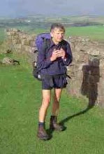
Left Kettlewell in light drizzle on a quite road heading south running along the east side of the River Wharfe until I reach Conistone where I crossed the river and joined the B6160. This was a rather busy road and I didn’t feel particularly safe. After about 1 ½ miles I was able to turn off onto a path to Skirethorns. I got slightly lost here, mistaking a permanent caravan park for the camp site. Finally got it sorted out and headed on to Threshfield Moor. The weather had improved by now though remained overcast. What initially started as a good 4 wheel track disappeared into a featureless heather landscape with no discernable path. I had to navigate using GPS to my turning point at Lane Head where the track was visible again. I headed south eventually joining a minor road to Hetton, where I had a snack in the pub. I then followed a slightly busier road to Gargrave, which needed care walking around the bends
At Gargrave I headed to the camp site to book in. I had to go to the co-op to get money from a machine to pay the campsite. I wanted to phone an old school friend (Derek) who lives fairly near here – too noisy with traffic outside so phoned inside the co-op while I did my shopping. I left a message on his answer phone. When I went to the till to pay, who should be there but Derek, though not as a result of the phone call! He had been to the campsite looking for me and they had directed him to the co-op. He shouted me a meal in the pub and we had a great time catching up on our old school days.
He also gave me another old school friends’ number (Pat) who I contacted and hopefully she and 3 other friends from school will join me for part of the walk tomorrow.
About my blog
CLL is the acronym for Chronic Lymphocytic Leukaemia. CLL is the most common cancer of the blood. However, unlike many other leukaemias, CLL is incurable. Innovative research is desperately needed to provide treatments which are more effective than the derivatives of chemical warfare agents currently in use. Research however costs money.
In 2009 I walked from John o'Groats in the north east of Scotland to Land's End in the south west of England. Hence the acronym JOGLE. The purpose of my walk was to make more people aware of this insidious disease and to encourage them to sponsor me by donating to the research groups I was supporting. It was a most enjoyable experience and I met some wonderful people. Together we raised over 2000 pounds for the cause. Thank you everyone!
In, 2010, the blog was being continued for those who may have be interested in following my walking holiday in Wales. This was not a charity walk.
Sadly this year, 2013, Alan Frost, a senior member of the Wednesday Loafers, our cancer support group, passed away. Many medics will tell you that CLL can be cured by a bone marrow transplant. Alan had battled with the cure for many years. More research is needed, but significant progress has been made since I started this blog.
CLL is still killing my friends. The organizations listed at the side of this blog would welcome any contributions you would like to make towards their research.
Please feel free to pass on the details of this site to anyone you think may be interested. The link is www.cancerwalker.com
_______________________________________________
_______________________________________________
Subscribe to:
Post Comments (Atom)
No comments:
Post a Comment